Pontiac
Butler County, Kansas, USA
- Found by MetDetect
- Human-verified · Marc Fries
- No meteorites recovered
- Fireball (UTC)
- 2024-12-02 19:16:23 ± 15 s GOES lightning mapper (GLM)
- Observed by
- How it was observed
- Radar searched
- KICT
- Meteorites
- none recovered
- MetDetect
- MetDetect RUN-42 test set, development result · radar KICT
How it was observed
- Video, type unknownTwo videos sent in by witnesses (Bixby, Oklahoma and Wichita, Kansas); camera type not stated.American Meteor Society, event 7432-2024 (archived copy): 2 videos
- SatelliteWeather-satellite lightning sensors (GOES) caught a 0.04-second flash from the fireball, which gives its exact time.NASA/SETI bolide database (GOES lightning mapper)
- Witnesses49 witness reports from Kansas and Oklahoma were sent to the American Meteor Society.American Meteor Society, event 7432-2024 (archived copy)
Fireball cameras are cameras built to record meteors, usually all-sky and calibrated. Casual video is footage or photos from cameras that were not (dash cams, doorbell and security cameras, phones); where a source does not say what kind of camera, it is listed as video of unknown type. Only what a source documents is listed; a missing label means nothing of that kind is documented, not that it did not exist.
Automated detection
MetDetect searched the KICT radar around the fireball time. It found the fall: its first pick, the echo it ranks most like falling debris, is the debris identified by hand, and the object grown from it holds 67% of the hand-identified cells.
- 137of the 206 hand-identified cells on KICT found
- 69hand-identified cells missed
- 53cells reported that were not identified by hand
- 72%of the cells it reports were identified by hand (purity)
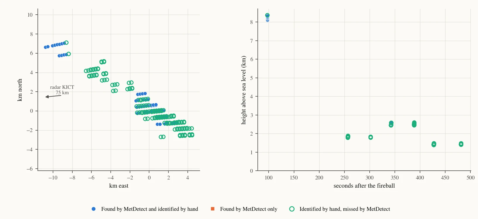
MetDetect RUN-42, 12 Nov 2026. Leave one fall out: every learned part was trained without the fall it is scored on. 30 of the 32 falls are the test set (dual-polarization radar, at least 10 hand-identified radar measurements on the radar searched); the other 2 are used for training only and are not in the headline numbers. The method was developed on these falls, so these are development results, not a blind test. The hand identification is the reference these numbers are graded against.
Dark flight
After the fireball goes dark, meteorites fall freely through the wind. Each radar cell is flown down to the ground through the winds of that day; the coloured areas show where stones of each mass most likely landed, and the black line runs from light to heavy stones (solid where the radar traced it, dashed where extended). The map shows both: (a) from MetDetect's cells on KICT, (b) from the radar cells identified by hand by Marc Fries on every NEXRAD radar labelled, in the same frame and colour scale. Each panel gives its search area for stones of 10 g and up (the 90% regions) and the recovered stones of 10 g and up inside it. The two search areas overlap by 25% (shared area over combined area).
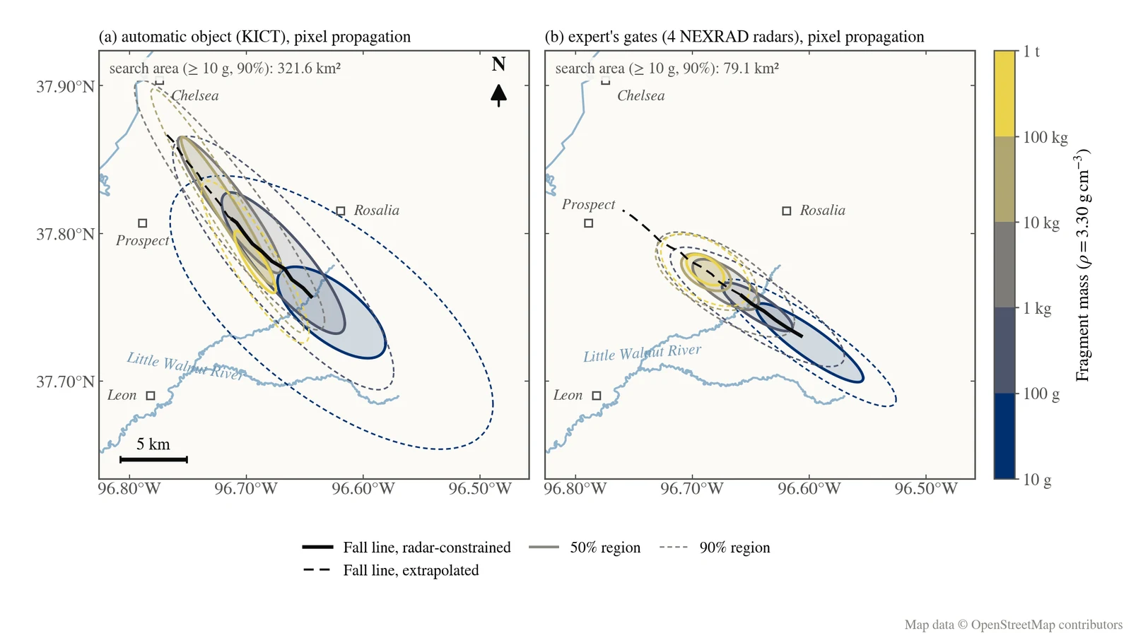
Pixel estimate, computed by P. Shober with MetDetect: winds from ERA5 (ECMWF), masses at the fall's assumed bulk density (on the colour bar). Preliminary: it does not fit the fireball itself, so the heavy end of the line is an extrapolation. Villages and rivers: © OpenStreetMap contributors.
Human identification
The radar signatures of this fall were identified by hand by Marc Fries. Read the original report (archived copy).
Meteorites
No meteorites reported (Fries 2025: a probable fall, not recovered).
Publications
Meteorite fall activity in U.S. weather radar data in 2024. 56th Lunar and Planetary Science Conference, abstract 1050
Know of a paper or a recovered meteorite we missed? Tell us.